
The points below are drawn from the report and its appendices themselves. Each one is a matter that the documents raise, leave open, or state differently in different places. They are not objections, and readers may or may not consider each one important.
Proposed new dwelling on Erf 3806 (portion of Erf 2916), Sea Vista, St Francis Bay
Closes 29 September 2026 (SAST) · Environmental authorisation, DEDEAT ref EC08/C/LN1/M/41-2026
The plain-language summary and the potential concerns on this page are prepared by ShapeSFB from the official documents. They are summaries, not official documents. The source documents are listed under Documents received below.
In short
- A private applicant wants to build a new multi-storey house of about 500 square metres, with a pool, decks and a pergola, on a canal-front erf in Sea Vista, St Francis Bay.
- The site sits inside the Kromme Estuary's Estuarine Functional Zone and is mapped as a Critical Biodiversity Area, which is why environmental authorisation is needed.
- The specialists say this one house on its own will not harm the estuary, but the aquatic specialist rates the cumulative risk from continued development in the zone as High.
- Several key numbers differ between the report and its appendices, including the distance to the high-water mark, the buffer width and the size of the building.
- Written comments on the draft report close on 29 September 2026.
What is being proposed?
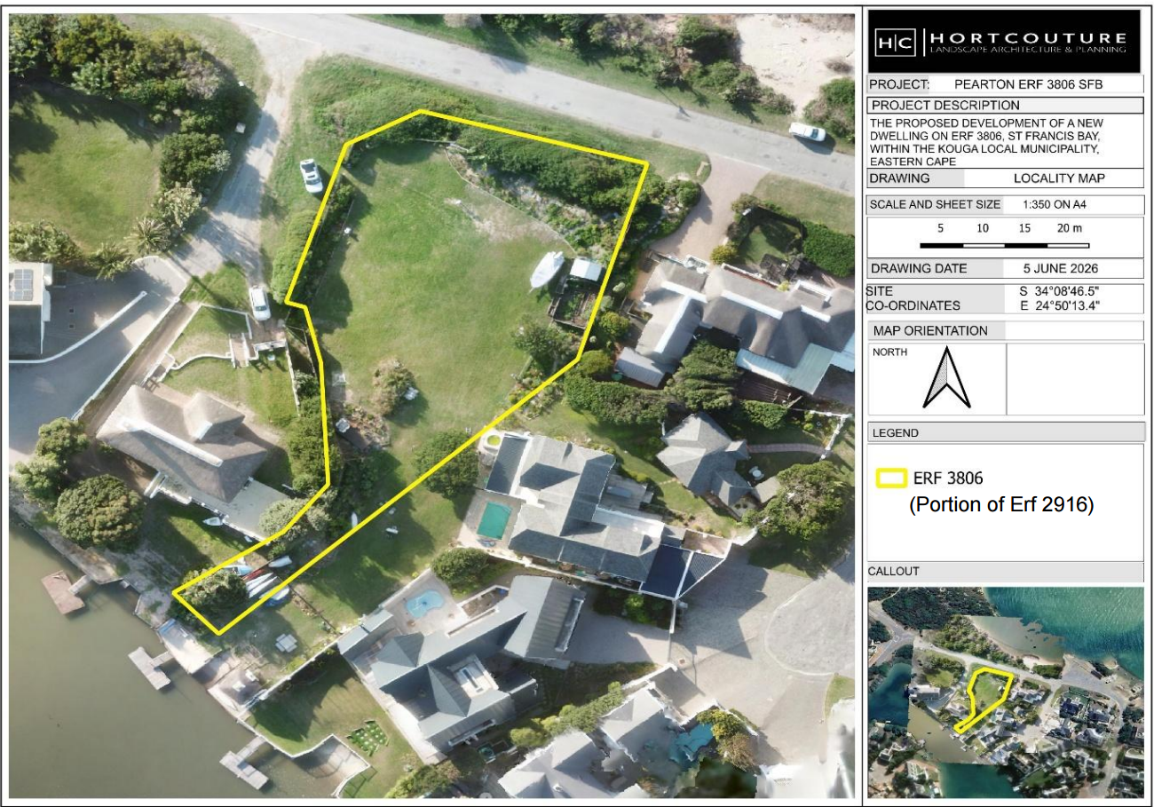
The applicant, a private individual, has applied to the Eastern Cape Department of Economic Development, Environmental Affairs and Tourism (DEDEAT) for environmental authorisation to build a new private home on Erf 3806 (a portion of Erf 2916), Sea Vista, St Francis Bay, in the Kouga Local Municipality (Draft Basic Assessment Report, p. 1 and p. 16).
The proposal is for a multi-storey brick and mortar dwelling with a total floor area of about 500 square metres, plus decks, patios and outdoor entertainment areas on the canal frontage, a swimming pool, hard landscaping, an enclosed pergola or covered structure on the canal frontage, solar power generation with backup, rainwater harvesting tanks, and connections to Kouga Local Municipality water, electricity, sewerage and refuse services (report p. 16). The total development footprint, including the house, decks, pool, pergola, access, services and hard landscaping, is given as roughly 600 square metres (report p. 16 and p. 100).
The property is privately owned, already zoned residential, and sits in an established residential area between two developed homes (report p. 27, p. 45 and p. 100). The report describes the site as a maintained landscaped garden rather than intact natural coastal vegetation (report p. 16). Only one build option is assessed, plus the compulsory "no-go" option of leaving the site as it is, which the report says is not preferred (report p. 102). The report says no alternative sites were considered because the property is already zoned residential (report p. 45).
Because the building footprint is larger than 50 square metres and lies within 100 metres inland of the high-water mark of an estuary, and because more than 5 cubic metres of material will be excavated or moved in that same 100 metre band, the project triggers listed activities 17(v)(e) and 19A(ii) of Listing Notice 1 (GN R327). This means a Basic Assessment has to be done before DEDEAT can decide (report p. 18).
The report says the build would create roughly 15 to 20 construction jobs worth about R1.2 million in wages, with 80 percent going to previously disadvantaged individuals, and an expected capital value on completion of about R10 million (report pp. 50 to 51). It states there would be no permanent operational jobs (report p. 51). The environmental assessment practitioner, Hort-Couture Landscape Architects and Planning CC, concludes that there are no fatal flaws and recommends that the development be authorised (report p. 105 and p. 113).
Key terms in this application
Plain-language explanations of technical terms used here. See the full glossary.
- Critical Biodiversity Area (CBA)
- Land that should stay natural to meet biodiversity targets. Land identified as needing to stay in a natural or near-natural state to meet the area's biodiversity targets. CBA 1 is the highest flag, usually irreplaceable or the best remaining option, so development there faces the strongest scrutiny. CBA 2 is important too, with a little more site-selection flexibility.
- Ecological Support Area (ESA)
- Land that supports the functioning of CBAs. Land that is not necessarily pristine but supports the functioning of Critical Biodiversity Areas or delivers ecosystem services such as water flow and habitat connectivity. ESA 1 is usually still largely natural; ESA 2 is often already degraded but still plays a supporting role and is frequently flagged for restoration.
- ECBCP
- Eastern Cape Biodiversity Conservation Plan. A provincial spatial biodiversity plan that maps the Eastern Cape by how important each area is for conserving ecosystems and ecological processes. It is a decision-support tool used by authorities and practitioners to judge whether a proposed land use is appropriate where it is proposed.
- EAP (Environmental Assessment Practitioner)
- The independent specialist who compiles the application. The independent professional appointed by the applicant to run the environmental assessment and public participation process and to compile the reports. The EAP must be objective, even though the applicant pays for the work.
- Basic Assessment (BA) and Basic Assessment Report (BAR)
- The assessment process and report for lower-impact activities. Basic Assessment is the shorter environmental assessment process used for lower-impact listed activities. The Basic Assessment Report (BAR) is the main document, describing the proposal, the receiving environment, the impacts, and the proposed mitigation.
- EMPr (Environmental Management Programme)
- The plan of measures and monitoring for the development. The Environmental Management Programme sets out the practical measures, responsibilities, monitoring and penalties for how a development must be built and operated to manage its environmental impacts.
- Competent authority
- The government body that decides the application. The authority empowered to decide the application. For most environmental authorisations in the Eastern Cape this is the Department of Economic Development, Environmental Affairs and Tourism (DEDEAT).
- Biodiversity offset
- Compensating for unavoidable biodiversity loss elsewhere. A measure of last resort in which unavoidable, significant residual loss of biodiversity is compensated for by securing and managing an equivalent area elsewhere. Guidance may require an offset where development in a Critical Biodiversity Area is unavoidable.
The site and what the specialists found
Erf 3806 lies inside the Estuarine Functional Zone of the Kromme Estuary, which is the area of land and water that the estuary needs to function (Draft Basic Assessment Report, p. 23 and p. 88). The Kromme Estuary is a permanently open system with an estuarine health score of 49, giving it a Present Ecological Status of Category D, meaning "largely modified" (report p. 23). It is still ecologically important and works as a fish nursery (report p. 24). The estuary's habitat covers about 421 hectares, including intertidal and supratidal saltmarsh, submerged Zostera capensis beds, reeds and sedges, sand and mud banks and open water (Appendix D, p. 59). Overall cumulative pressure on the estuary is rated High, with freshwater inflow and pollution rated Very High (Appendix D, p. 59).
Under the Eastern Cape Biodiversity Conservation Plan, most of the site is mapped as a Critical Biodiversity Area 1 on land, and as Ecological Support Area 1 with part Critical Biodiversity Area 1 for aquatic biodiversity (report pp. 38 to 41). The management objective for a Critical Biodiversity Area 1 is to keep it in a natural state, and the plan says that if land use in such an area is unavoidable, a biodiversity offset must be designed and implemented (report p. 34). The report argues that the site is already transformed and no longer works as functional Critical Biodiversity Area 1 habitat, so the development is consistent with the plan's land use guidelines (report p. 42).
The national Screening Tool rated the site Very High for animal species, aquatic biodiversity, palaeontology and terrestrial biodiversity, and High for agriculture, civil aviation and plant species (report p. 40). The Screening Report itself listed eleven specialist assessments, including landscape and visual, marine, avian, geotechnical and socio-economic studies (Appendix D, p. 35). The practitioner concluded that only three specialist inputs were warranted: a marine and aquatic assessment, a combined terrestrial biodiversity assessment, and a heritage screener with a possible palaeontological assessment (Appendix D, pp. 24 to 25).
The aquatic specialist visited the site on 28 May 2026 between 15:00 and 15:30, about an hour after high tide, and worked by visual and drone inspection with no destructive sampling (Appendix D, p. 52). The specialist submitted a compliance statement rather than a full specialist assessment, on the basis that the surrounding environment is entirely transformed (Appendix D, p. 48). The finding is that on its own the development will have no impact on the estuary during construction or operation, provided the recommended measures are followed (Appendix D, p. 62). The same specialist states that the risk to the estuary from the cumulative impact of development inside the Estuarine Functional Zone in the lower and middle reaches "should be regarded as HIGH", and recommends that the local authority take proactive measures to prevent additional development in that zone (report p. 25 and p. 69; Appendix D, p. 62).
The terrestrial biodiversity compliance statement, based on a single winter site visit on 28 May 2026, concludes that the site is better described as having Low terrestrial biodiversity sensitivity despite the Very High screening rating (Appendix D, p. 137 and p. 172). Protected plants were recorded on site: Aloe arborescens, Cotyledon orbiculata, Cynanchum obtusifolium and Strelitzia nicolai, protected under Provincial Nature Conservation Ordinance 19 of 1974, and Sideroxylon inerme, protected under the National Forests Act 84 of 1998 (report pp. 29 to 30; Appendix D, p. 149). Permits would be needed if the milkwood has to be removed (report p. 106).
On heritage, the heritage consultancy CTS Heritage found the development does not trigger section 38(1) of the National Heritage Resources Act and recommended no further heritage studies (Appendix D, p. 78). The Eastern Cape Provincial Heritage Resources Authority responded on 6 August 2026, exempting the development from further heritage assessment under section 38(2b) of the Act, subject to conditions including notice of commencement, heritage induction for ground crew, a chance finds protocol, monitoring during clearing and excavation, and a final heritage compliance report (Appendix D, pp. 123 to 124). Historical aerial photographs from 1961, 1971 and 1998 show no development on the property since 1961, so no structure older than 60 years is affected (Appendix D, p. 93).
The impact tables record no High or Very High impacts, with or without mitigation (report p. 94). With mitigation, most impacts are rated Low. The visual impact in the operational phase is rated Moderate both with and without mitigation, because it is permanent (report pp. 79 to 80). Without mitigation, stormwater and water quality, loss of topsoil, noise, health and safety, and groundwater contamination reach Moderate (report pp. 78 to 93). The report says the development's contribution to greenhouse gas emissions is negligible, and notes that extreme weather and sea level rise could flood adjacent properties along the canal and estuary (report pp. 71 to 73).
Potential concerns and unresolved questions
1. Distance to the high-water mark is stated two different ways
The report states in one place that the northern boundary is approximately 7 to 9 metres from the high-water mark (report p. 88), and in other places that the site is 41 metres from the high-water mark (report p. 87, p. 101, and pp. 24 to 25). The 41 metre figure is the one used to argue that a functional ecological strip is retained between the development and the estuary. The aquatic specialist also records that the exact position of the high-water mark is unknown and that the vegetation edge and canal walls were used as a stand-in (Appendix D, p. 52).
You may wish to ask DEDEAT and the practitioner to confirm, with a surveyed measurement shown on a plan, the actual distance from the proposed structures to the high-water mark, and to state which figure the assessment relies on.
Main reference to cite: Draft Basic Assessment Report, p. 88
2. Buffer width given as 41 metres in one document and 32 metres in another
The main report describes the ecological component as being retained within 41 metres of the high-water mark (report p. 87), while the Construction Environmental Management Programme identifies a 32 metre vegetated buffer next to the Kromme Estuary as the functional ecological component and a strict no-go area (Appendix F, p. 24 and p. 66). The terrestrial statement separately says the site is within 32 metres of the Marina Glades canal (Appendix D, p. 165). A no-go area cannot be demarcated on site if its width is uncertain.
You may wish to ask that any authorisation state a single, precise buffer width and that the buffer be shown on a survey plan before construction starts.
Main reference to cite: Appendix F, Construction Environmental Management Programme, p. 24
3. Cumulative estuary risk rated High but no site-specific response
The aquatic specialist finds that this development on its own will have no impact, but that the risk to the estuary from the cumulative impact of development inside the Estuarine Functional Zone should be regarded as HIGH, and recommends that the local authority act to prevent additional development in that zone (report p. 25 and p. 69; Appendix D, p. 62). The report's answer to this High cumulative risk is a recommendation directed at the municipality, not a measure attached to this application.
You may wish to ask DEDEAT how a High cumulative risk inside the Estuarine Functional Zone is weighed when deciding an individual application, and whether any condition on this authorisation is proposed to address it.
Main reference to cite: Draft Basic Assessment Report, p. 69
4. Biodiversity offset required by the plan but not discussed
The Eastern Cape Biodiversity Conservation Plan states that where land use activities in a Critical Biodiversity Area 1 are unavoidable, a biodiversity offset must be designed and implemented, depending on expert opinion of the site's condition (report p. 34). The report does not propose or assess an offset anywhere. It argues instead that because the footprint is transformed, no functional Critical Biodiversity Area 1 habitat is lost, so the development is consistent with the plan (report p. 42).
You may wish to ask DEDEAT to confirm whether it accepts that no offset is required in this case, and to record the reasons in any decision.
Main reference to cite: Draft Basic Assessment Report, p. 34
5. Floor area and footprint figures do not match the plan
The narrative text gives a dwelling of about 500 square metres and a total footprint of about 600 square metres (report p. 16 and p. 100; Appendix F, p. 12). The preliminary plan attached to the Construction Environmental Management Programme shows a ground floor of 358 square metres, a first floor of 293 square metres and a gazebo of 20 square metres, totalling 681 square metres on an erf of 1697 square metres (Appendix F, p. 73). The heritage report records a total development surface area of 600 square metres (Appendix D, p. 80). The assessed footprint is what any authorisation would be tied to.
You may wish to ask that the actual built footprint and floor areas be stated consistently across the report, the plan and any authorisation, and confirmed against the building plans.
Main reference to cite: Appendix F, Construction Environmental Management Programme, p. 73
6. Template content from an unrelated project appears in the specialist reports
The Site Sensitivity Verification Report carries headers referring to "PIPELINES PHASE 4" and a Port Alfred sewerage infrastructure upgrade (Appendix D, pp. 3 to 26), describes the main watercourse as the Kowie Estuary and refers to the Wharf Street corridor and West Bank (Appendix D, p. 9), and in its Purpose section refers to "Farm Portion 3/666, Southwell, Local Ndlambe Municipality" (Appendix D, p. 12). The Screening Report gives the project title as "ERF 3809 SFB" (Appendix D, p. 30). The management programme also contains blasting noise controls and Public and Private Open Space no-go conditions that do not relate to this house (Appendix F, pp. 37 to 38 and p. 62).
You may wish to ask that the specialist reports be corrected and reissued for comment so that it is clear which findings were actually made for this site.
Main reference to cite: Appendix D, Specialist Reports, p. 12
7. Specialists describe the site differently: developed or undeveloped
The aquatic specialist describes Erf 3806 as "currently an undeveloped residential erf with no existing dwelling or other permanent built structures" (Appendix D, p. 48), and the terrestrial statement calls it an undeveloped erf (Appendix D, pp. 135 to 136). The Site Sensitivity Verification describes the site as already largely developed and containing existing structures, and as sitting within a fenced space accommodating two other residences (Appendix D, pp. 18 to 19 and p. 26; Appendix G, p. 9 and p. 25). One page also states that almost half the property contains natural vegetation with only a small historical footpath as disturbance (report p. 88), which sits awkwardly with the repeated statement that no intact natural vegetation remains (report p. 28).
You may wish to ask the practitioner to state clearly what is currently on the site and how much of it retains natural vegetation, since the "already transformed" argument rests on this.
Main reference to cite: Appendix D, Specialist Reports, p. 48
8. Compliance statements used instead of full specialist assessments
The Screening Tool rated aquatic biodiversity, terrestrial biodiversity, animal species and palaeontology as Very High and listed eleven specialist assessments (report p. 40; Appendix D, p. 35). The practitioner reduced this to three inputs (Appendix D, pp. 24 to 25), and the aquatic and terrestrial specialists each produced a compliance statement rather than a full assessment (Appendix D, p. 48 and pp. 136 to 137). The aquatic site visit lasted about 30 minutes (Appendix D, p. 52) and the terrestrial visit was a single winter visit (Appendix D, p. 172).
You may wish to ask DEDEAT to confirm that it accepts the compliance statement route and the reduced list of specialist studies, and to record its reasons.
Main reference to cite: Appendix D, Specialist Reports, p. 48
9. Terrestrial statement declares no gaps in knowledge while the main report lists several
The terrestrial biodiversity compliance statement states that "there are no assumptions, uncertainties or gaps in knowledge" (Appendix D, p. 173). The main report, by contrast, acknowledges seasonal variability, reliance on screening tools and secondary datasets that may not reflect fine scale conditions, a limited number of site visits that do not constitute a long-term monitoring dataset, and that geotechnical and groundwater pathway investigations fall outside the scope (report pp. 103 to 104). The aquatic specialist lists several assumptions, including that the exact high-water mark is unknown and that a closed conservancy tank will be used (Appendix D, pp. 52 to 54).
You may wish to ask that the gaps and assumptions be stated consistently across the specialist reports, and that any authorisation conditions be linked to the assumptions the specialists relied on.
Main reference to cite: Appendix D, Specialist Reports, p. 173
10. Sanitation method is assumed rather than confirmed
The aquatic specialist's no-impact finding for the operational phase depends on assumptions: that a closed conservancy tank rather than a septic tank is used, that it sits in the northern half of the site at least 45 metres from the estuary edge, that it is regularly serviced, and that swimming pool backwash is linked to it (Appendix D, pp. 52 to 54 and p. 61). Elsewhere the report states that sewage will be discharged into the existing municipal sewerage network (Appendix F, p. 14 and report p. 56).
You may wish to ask which sanitation method will actually be used, and to request that the specialist's assumptions be written into any authorisation as enforceable conditions.
Main reference to cite: Appendix D, Specialist Reports, p. 53
11. Municipal service capacity is assumed, not verified
The report records an assumption that municipal water supply, electricity and sewerage infrastructure have sufficient capacity to accommodate the development (report p. 103). The findings do not include a capacity confirmation from Kouga Local Municipality. The report also identifies cumulative demand on municipal infrastructure as a cumulative impact (report pp. 69 to 70), and the aquatic specialist flags cumulative risk from wastewater spills caused by damaged infrastructure or flooding (Appendix D, pp. 61 to 62).
You may wish to ask that written confirmation of bulk water and sewer capacity from Kouga Local Municipality be placed on the record before a decision is taken.
Main reference to cite: Draft Basic Assessment Report, p. 103
12. Palaeontology rated Very High but no full assessment done
The Screening Tool rated palaeontological sensitivity Very High (report p. 40), while the SAHRIS map shows the site as moderately sensitive (report p. 42). The Site Sensitivity Verification says a full palaeontological impact assessment "may be required" pending the heritage authority's review, and that ECPHRA will guide further investigation (Appendix G, p. 19 and p. 24). ECPHRA subsequently exempted the development from further heritage assessment under section 38(2b) of the National Heritage Resources Act, subject to conditions (Appendix D, p. 123). The heritage report also ticks section 38(8) as applicable without explanation (Appendix D, p. 80).
You may wish to ask for confirmation that the ECPHRA exemption covers palaeontology as well as archaeology, and that the ECPHRA conditions are carried into any authorisation.
Main reference to cite: Appendix D, Specialist Reports, p. 123
13. Flood and sea level rise risk is noted but not assessed for this site
The report notes that extreme weather and sea level rise could cause flooding of adjacent properties given canal and estuary levels, and points to the municipality's Flood Plan and Disaster Management Plan (report p. 71). The aquatic specialist records that the Estuarine Functional Zone extends up to 8 metres above mean sea level in places in the Sea Vista area (Appendix D, p. 52), while the site's minimum elevation is given as about 2 metres above sea level on the northern boundary (report p. 19). No flood line or storm surge assessment is presented for the property.
You may wish to ask for the applicable flood line and a storm surge or sea level rise assessment for this erf, and for confirmation of the finished floor level relative to it.
Main reference to cite: Draft Basic Assessment Report, p. 71
14. Climate change section is generic
The climate change assessment repeatedly concludes that the impact and the contribution to emissions are negligible given the small scale of the development, and states that the activity "will not release any GHG emissions into the atmosphere" (report pp. 72 to 73). No site-specific calculation or quantification is provided to support this, and the statement that no emissions at all will be released is not reconciled with a 12 month construction programme (Appendix F, p. 62).
You may wish to ask for the basis of the negligible finding to be shown, or for the section to be revised so that it reflects the actual project.
Main reference to cite: Draft Basic Assessment Report, p. 72
15. Job numbers are given inconsistently
The report states 15 to 20 construction jobs worth about R1.2 million with 80 percent to previously disadvantaged individuals (report pp. 50 to 51), and elsewhere states 10 to 15 temporary jobs (report p. 47 and p. 52). It confirms zero permanent operational jobs (report p. 51). These are the figures the report relies on for its beneficial socio-economic ratings.
You may wish to ask that the employment figures be stated consistently, since they support the report's positive socio-economic findings.
Main reference to cite: Draft Basic Assessment Report, p. 51
16. Audit timeframe stated two ways in the management programme
The Construction Environmental Management Programme requires the final post-construction audit report to be submitted within one month of completion in one section (Appendix F, p. 37) and within three months in another (Appendix F, p. 45). The document is marked "First Draft" with the final date for the environmental authorisation left blank (Appendix F, p. 3).
You may wish to ask that the audit and reporting timeframes be fixed to a single figure in the version that is submitted for approval.
Main reference to cite: Appendix F, Construction Environmental Management Programme, p. 45
17. Vegetation baseline described differently across reports
The main report gives the closest terrestrial vegetation type as St Francis Strandveld with an Endangered status per the 2026 National Biodiversity Assessment (report p. 29), while the terrestrial compliance statement describes St Francis Strandveld as Critically Endangered (Appendix D, p. 145) and lists its threat activities as "Not yet assessed" (Appendix D, pp. 146 to 147). The site itself is mapped as Non-Terrestrial Estuarine Functional Zone rather than a terrestrial vegetation type (report pp. 27 to 28).
You may wish to ask which threat status is correct and which National Biodiversity Assessment edition was used, so that the baseline the assessment relies on can be checked.
Main reference to cite: Appendix D, Specialist Reports, p. 145
18. Invasive species recorded in some reports but not in others
The main report and the management programme identify invasive species on site, including Nerium oleander described as present "in abundance" and Schinus terebinthifolia (report p. 106; Appendix F, p. 47). The terrestrial biodiversity compliance statement states that no listed invasive alien plant species were recorded during verification (Appendix D, p. 174). The mitigation measures require invasive species eradication before construction and monitoring afterwards (Appendix F, p. 27 and pp. 46 to 47).
You may wish to ask for a single agreed invasive species list for the site so that the clearing and monitoring obligations can be checked against it.
Main reference to cite: Appendix D, Specialist Reports, p. 174
19. Depth of topsoil unknown
The report notes that the depth of topsoil on site is unknown (report p. 80), while the mitigation measures rely on stripping, stockpiling and reusing topsoil to rehabilitate disturbed areas (report pp. 80 to 81). Without mitigation, loss of topsoil is rated Moderate (report p. 81).
You may wish to ask that the available topsoil volume be confirmed before clearing, and that any shortfall for rehabilitation be made up from an approved source.
Main reference to cite: Draft Basic Assessment Report, p. 80
Mitigation and biodiversity offset
A ShapeSFB summary of how the report proposes to manage impacts, following the mitigation hierarchy. This helps distinguish genuine legal and ecological measures from generic promises. Tap a heading to read the detail.
1. Residual impact rating (after mitigation)
"Low" for most impacts after mitigation, with visual impact in the operational phase remaining "Moderate" (Assessment Report Tables 13 to 18, pp. 75-82, and Table 28, p. 94: 22 Low and 5 Moderate with mitigation, no High or Very High). The terrestrial compliance statement determines the site is of "Low Terrestrial Biodiversity Sensitivity" (Appendix D pp. 137, 172, 177). The aquatic specialist records "NO IMPACT" on the estuary with mitigation for construction and operation, while rating the cumulative risk of estuarine impact from developments within the EFZ as "HIGH" (Appendix D p. 62; Assessment Report pp. 25, 69). The EMPr states "no medium or high significance residual impacts are anticipated following mitigation" (EMPr p. 67).
2. Biodiversity offset considered
No
3. Proposed monitoring and enforcement
- Environmental Control Officer appointed by the applicant to monitor compliance during construction, with periodic inspections recommended during operation (Assessment Report pp. 89, 105, 110; EMPr pp. 18, 21, 35-37)
- ECO site visits and audits at least once per month, preferably twice monthly, over the approximately 12 month construction period (EMPr pp. 21, 62)
- ECO audit reports submitted quarterly to DEDEAT, with a final post-construction audit within one month (p. 37) or within three months (p. 45) of completion, an internal inconsistency in the EMPr
- ECO must inform DEDEAT in writing prior to construction commencing, with fourteen days written notice before commencement (EMPr pp. 19, 36, 42)
- Non-compliance to be notified to DEDEAT in writing within 30 days with reasons (EMPr pp. 36, 42)
- Environmental performance indicators and thresholds: no visible sediment leaving the site boundary, no stormwater discharge into the buffer zone, no erosion gullies, no hydrocarbon or cement soil contamination and no disturbance within the demarcated buffer; breaches require corrective action and ECO notification within 24 hours (EMPr p. 33)
- Non-compliance penalty schedule imposed on the contractor, for example R10 000 for operating in a no-go area and R10 000 for spillage, pollution or damage to a watercourse through negligence, with repeat offences doubled to a maximum of R100 000 (EMPr pp. 62-63)
- Photographic baseline and ongoing photographic record required (EMPr pp. 22, 62)
- ECO to identify and record invasive species and report to authorities, with post-completion monitoring of the site and surrounding areas for invasive species and rapid response protocols during operation (Assessment Report pp. 76, 88; EMPr pp. 27, 40)
- Regular inspection and maintenance of stormwater controls including SUDS and settling ponds (Assessment Report p. 78)
- Post-construction monitoring of lighting levels to ensure no negative effects on residents, the estuary or nocturnal wildlife (Assessment Report pp. 79, 107)
- Dust levels monitored during peak use periods (Assessment Report p. 82)
- Post-construction monitoring by the ECO to confirm disturbed areas are stabilised and rehabilitated (Assessment Report p. 111; Appendix D p. 176)
- All waste removal, handling and disposal certificates submitted to the ECO and included in compliance monitoring reports (Assessment Report p. 85)
- Heritage monitoring during vegetation clearing and excavations, heritage induction and training for ground crew, Heritage and Fossil Chance Finds Protocol, notification of ECPHRA of the commencement date and a final heritage compliance report post-construction (Assessment Report p. 113; ECPHRA response pp. 123-124)
- Sewerage infrastructure to be regularly maintained and conservancy tank servicing capacity ensured; any foul odours or leaks around the conservancy tank investigated and repaired immediately (Assessment Report p. 112; EMPr p. 59)
4. Impact avoidance
- Demarcate the 32 m vegetated buffer adjacent to the Kromme Estuary as a strict no-go area before any works, with no construction, access, stockpiling, storage or disturbance permitted (EMPr pp. 24, 66)
- Confine all construction strictly to the approved development footprint; areas outside Erf 3806, neighbouring properties and the adjoining canal are no-go areas (Assessment Report p. 110; EMPr p. 24; Appendix D p. 175)
- No stormwater runoff may discharge into or through the 32 m buffer zone (EMPr p. 25)
- No storage of construction equipment, materials, rubble, spoil, fuels or hazardous substances outside the approved area or where they may enter the canal (Assessment Report p. 110)
- No dumping of garden refuse, construction waste or rubble beyond the property boundary or into the canal, and no burning of waste on site (Assessment Report pp. 86, 110)
- Prevent clearing of vegetation along the estuary adjacent to the development site (Assessment Report p. 106)
- Avoid lighting within 32 m of the estuary or near dense vegetation (Assessment Report p. 109)
- No servicing or refuelling of vehicles or machinery on site outside designated bunded areas (Assessment Report p. 91; EMPr pp. 32, 48)
- Limit disturbance strictly within the approved footprint and remove only vegetation essential for construction, with no unnecessary removal of indigenous vegetation (Assessment Report pp. 16, 76, 78)
- Retain protected plant species in situ where feasible (Appendix D pp. 174-175)
5. Impact minimisation
- Plant search and rescue by a suitably qualified person prior to any site clearance, with permits from the competent authority where protected species such as Sideroxylon inerme must be removed (Assessment Report pp. 74-75, 106, 110; Appendix D pp. 174-175)
- Solid hoarding or barrier system erected around the construction footprint (Assessment Report pp. 75, 87, 106)
- Vegetation clearing limited to the minimum area required within the approved building footprint and done progressively (Assessment Report p. 106; Appendix D p. 175)
- Erosion and sediment control using silt fences, sediment traps and erosion control blankets before and during construction (Assessment Report p. 77)
- Sediment barrier along the southern edge bordering the canals during construction until the site is stabilised (Assessment Report p. 112; Aquatic report pp. 60-61)
- Sustainable Drainage Systems including swales, attenuation ponds, permeable paving and rainwater harvesting, with post-development stormwater discharge not exceeding pre-development volumes (Assessment Report pp. 77, 106)
- Cement mixing only on a non-permeable surface at the northern end of the property, no mixing on bare ground, spills cleaned by hand and machinery washed off site (Assessment Report p. 112; Aquatic report p. 61)
- Machinery placed on drip trays with a fine sand layer to trap hydrocarbons, spills cleaned manually and disposed of off site (Assessment Report p. 112; Aquatic report p. 61)
- Hazardous materials stored in bunded impermeable areas with 110% containment capacity, spill kits on site at all times and staff trained in their use (Assessment Report pp. 86, 90-91)
- Portable toilets positioned away from the estuary and drainage lines on impermeable surfaces; conservancy tank, if used, placed on the southern portion of the erf as far from the estuary as possible (Assessment Report pp. 90, 92-93); aquatic specialist assumes a closed conservancy tank in the northern half at least 45 m from the estuary edge (Aquatic report pp. 52-53)
- Dust suppression by watering dust-generating surfaces at least three times daily during dry periods and wetting rubble before transport; construction vehicle speed limited to 30 to 40 km/h (Assessment Report p. 108; EMPr pp. 31, 49)
- Noise limited to municipal construction hours (08:00 to 17:00 weekdays, no weekends or public holidays), not exceeding 85 dB, with adjacent owners within 50 m notified in advance (Assessment Report p. 107; EMPr pp. 30, 37, 45, 48)
- External lighting downward-directed, shielded, warm-coloured at 3000K or less and full cut-off (Assessment Report pp. 87-88, 109)
- Neutral earth-toned finishes, low roof profiles, minimal protrusions and compliance with height restrictions (Assessment Report p. 79; EMPr pp. 29, 48, 51-52)
- Environmental induction for all construction staff (Appendix D p. 176)
- ECO to identify and monitor invasive species (Assessment Report p. 76)
6. Rehabilitation
- Stockpile viable topsoil and reuse it to rehabilitate disturbed and landscaped areas after construction (Assessment Report pp. 80-81, 90, 106; EMPr pp. 27-28, 48)
- Stabilise and revegetate disturbed areas with indigenous and endemic species as soon as possible after construction, with the ECO approving the final planting list and layout (Assessment Report pp. 75-78, 80, 90, 106)
- Biodegradable geo-jute or soil saver fabric erosion control on slopes steeper than 1:10 (Assessment Report p. 80; EMPr pp. 29, 48)
- Soil conditioning after construction using composted mulch and organic soil enhancers (Assessment Report pp. 80, 107)
- Eradicate alien invasive species (Nerium oleander, Schinus terebinthifolia) before construction and control or remove any that establish afterwards (EMPr pp. 27, 39, 46-47; Appendix D p. 175)
- Close and rehabilitate footpaths traversing the saltmarshes in line with Van Niekerk et al. (2019) (Assessment Report p. 112; EMPr p. 59)
- Final closure includes site cleaning and re-establishment of landscaping to original condition, signed off by the principal agent and ECO (EMPr p. 68)
7. EAP's reason
The EAP argues that although the site is mapped as CBA1, the development footprint is already largely transformed maintained garden and "does not retain the ecological characteristics required to meet biodiversity targets", so the CBA designation reflects "strategic biodiversity planning objectives rather than the present ecological functionality of the site" (pp. 38-39). On that basis "the development footprint is largely transformed and no longer meets the functional requirements of a CBA1 area. The proposed development therefore does not result in the loss of functional CBA1 habitat and is considered consistent with ECBCP land use guidelines" (p. 42), with the functional ecological component retained within the 32 m to 41 m vegetated buffer from the high-water mark, which is protected as a strict no-go area (p. 87; EMPr pp. 24, 66-67). The EAP further relies on the small scale and infill nature of the project within an existing urban footprint, the absence of direct works in the estuary, the aquatic specialist's finding of no impact with easily implementable mitigation, and management of residual risk through the EMPr and ECO oversight, concluding that "no fatal flaws have been identified", that residual impacts are low and manageable via the EMPr, that "the proposed development is not expected to generate any unacceptable environmental impacts", and recommending that the dwelling "should be authorised" (pp. 72, 105, 113; Appendix G pp. 9, 25).
8. Page references
Assessment Report pp. 34, 38-39, 42, 74-82 (mitigation and impact tables), pp. 86-94, 105-113 (mitigation, monitoring, EAP recommendation), pp. 69-70 (cumulative impacts); Appendix F EMPr pp. 24-33, 37, 42-52, 56, 59-63, 65-68; Appendix D pp. 22-25, 48, 52-54, 59-62 (aquatic), pp. 123-124 (ECPHRA), pp. 174-176 (terrestrial mitigation and monitoring); Appendix G pp. 6, 8-9, 15, 23-25
Your role
This is a Draft Basic Assessment Report. It has been released for public comment before DEDEAT makes a decision. This is the point at which members of the public can put questions, corrections or requests on the record, and the practitioner must record them and respond in the Comments and Responses Report that goes to the authority.
The public participation notice gives a 30 day comment period on the draft report, starting 28 August 2026 and closing 29 September 2026 (public participation notice, p. 1).
Comments carry the most weight when they are specific. Where you can, name the page or section of the report you are talking about, say what the problem or question is, and say what you would like the decision-maker to do about it, for example ask for a figure to be corrected, ask for an extra study, or ask for a condition to be attached to any authorisation.
You do not have to be an expert. Local knowledge about flooding, canal water quality, the estuary and the surrounding streets is directly relevant information that the report itself may not contain.
ShapeSFB is neutral. We do not tell you what to say. If you submit through this platform, your comment is forwarded to the contact listed on the notice, and you should keep a copy of your own submission and any acknowledgement you receive.
Documents received
Official documents received from the EAP or the competent authority. Every project shows at least the public notice and the principal assessment or application document, where both have been received.
- Background Information Document
- Invite as I&AP ERF 3806 (PORTION OF ERF 2916)
- Invite Comments ERF 3806 (PORTION OF ERF 2916)
- Draft Basic Assessment Report
- APPENDIX A - SITE PLAN
- APPENDIX B - SITE PHOTOGRAPHS
- APPENDIX C - PRELIMINARY PLAN
- APPENDIX D - SPECIALIST REPORTS
- APPENDIX E -PPP AND C&R TRAIL
- APPENDIX F - CONSTRUCTION ENVIRONMENTAL MANAGEMENT PROGRAMME
- APPENDIX G - OTHER INFORMATION
Have your say
1 submission has been made so far.
Your submission will be delivered to: The environmental assessment practitioner (Hort-Couture Landscape Architects and Planning CC); The public participation officer (Hort-Couture Landscape Architects and Planning CC).
You can comment now without registering separately. Submitting your comment also records you as an Interested and Affected Party, so you are notified of the outcome.
Know someone this affects? Share it so they can take part too.